
** Please note that this is an archive of the CANTAB publication and contains out-of-date information **
CANTAB RAMBLER
A-roaming, A-roaming..
It has been flattering to receive several anxious enquiries this Summer as to whether recipients of Cantab Rambler have missed an edition! The answer is, “No, sorry”. There have been no Cantabs since the May edition, as your editor has been away walking in Cumbria, Scotland, Austria, and more recently in Somerset, and catching up with work at home between trips. However, here is the twentieth issue of this private magazine, which will continue to appear at intervals whilst the demand remains.
Whilst many of us from East Anglia prefer our holidays in hills or mountains, relishing the contrast of scenery, and the demands of hill-climbing, I can recommend Somerset for having both uplands and flat lands. The Levels are an interesting comparison with the fens, grass & cows replacing arable fields in the wetter climate, but with some good hill-climbing in the limestone Mendips, and sandstone Quantocks. August and September finds the Quantocks glowing with heather and gorse in bloom, and dry footing everywhere. In the more popular tourist locations, the paths were excellent, with good signposting and way-marking. However, away from the “honey-pot” localities, signing of paths was sparse, and we found several overgrown stiles and hedge-gaps, to say nothing of a bridge with a large hole in the middle, and a right-of-way with a missing bridge.
Each evening on holiday, we took a few minutes to compile a list of problems with grid references from our new Explorer maps. On reaching home, it did not then take too long to send 17 problems to Somerset County Council, as the responsible Highway Authority, with a copy to the Area Secretary of Somerset Ramblers’ Association. The addresses are in the Ramblers’ Handbook. Can I encourage you to do likewise with your holiday destinations? There is a strong feeling that County Councils take more notice of tourists’ complaints than those of residents, as being a source of revenue into the area.
Path Problems in Cambridgeshire
It is not only Somerset that has path problems: we can find plenty at home this Autumn.
Most of you will know that Roger and I are Ramblers’ Association Footpath Secretaries for the 100 parishes of South Cambridgeshire. Generally, I regard the nitty-gritty of path problems to be rather dry fodder for Cantab which is designed to inform and entertain. However, in this issue, I seek to illustrate the repetitive problems we encounter, and ask for suggestions as to how long-term solutions might be obtained. In Cambs, the problems are no longer generally those of missing bridges, or of statutory signposting where a path leaves a county road. Path conditions are our problem – overgrowth in Summer; ploughed up paths in Winter. Here are some typical examples.
Fen Rivers Way
Duncan Mackay of the Fen Rivers Way working party, was embarrassed to receive a complaint from the North of England from a purchaser of the guide book. The walker had started in Cambridge but only got as far as just beyond Bottisham Lock to discover considerable overgrowth on the path. He had given up, and returned from Waterbeach, and never completed the walk. This complaint, one of many, occurs after similar complaints in Summer 2002, and following promises from Cambridgeshire County Council that all would be well this year. We are told that one of the vegetation “cuts” was made during the dry weather of April, when there had not been much growth, and clearly only one more cut through the whole of the Summer was inadequate.
The section of the path in Norfolk is reported as being in good condition. If Norfolk can do it, why not Cambs?
Councillor Complains of Sawston paths
While we were away, the Cambridge Evening News of 19 August published a letter from Councillor Sally Hatton of Sawston, complaining of nettles and overhanging vegetation on several Sawston paths. She wrote, “Very high nettles and overhanging branches need to be cleared from footpath 11, which runs between Church Lane and Babraham Road. Footpath 3, running between Hillside and Martindale Way needs to be cleared of overhanging branches etc, which in some cases, render it very difficult to negotiate the path.” The writer continues that these are only 2 examples of problems, which were reported to the County Council’s team 12 months ago, and still no action has been taken.
Whittlesford Moor
I wrote recently to Cambs.C.C. complaining of the state of Footpath 6 in Whittlesford. This attractive path passes through woodland, then follows two sides of a large arable field, which has been fallow for several seasons, and had a good trodden grassy path developed along the field edges. This field has now been ploughed up, and the field-edge path with it, so that it is now actually dangerous to teter on the edge of a deep water-filled ditch, and laborious in the ploughland. This type of problem happens regularly in the Autumn, and once the path is ploughed up, the surface is ruined at least for that Winter, and several seasons may elapse before the good surface can be re-established.
Yes, I received a reply. The problem had been passed to the local representative in the “P3” (Parish Path Partnership) scheme. The odds are, without badgering, I will never hear anything further, and the path will be in the same un-usable state all Winter. However, at the foot of the letter was the standard line “Should you require any more information, then please don’t hesitate to contact me”. So we e-mailed back our thanks, and asked for a monthly up-date!
Bourn Paths
In early August we were in Bourn, to find that the harvest was gathered in, and already fields had been ploughed, the stubble turned in and the field “cultivated” (i.e. reduced to a fine tilth, ready to receive the seed for the next season). The law states that where a path crosses such a field, the line of the path should be “reinstated”, defined, and the surface made good within 24 hours. (But after the first operation, the farmer has 2 weeks in which to reinstate). Clearly, no reinstatement had occurred. We complained to Cambs.C.C. on 6 August but by 1 September, had received no acknowledgement or reply.
This lack of reinstatement of cross-field paths happens all over the County. The Countryside Services Team send out letters of reminder to farmers in the Spring, and then tractor wheelings may appear, and the line of the path may be cut in the crop. But meanwhile the field path has been unmarked and often unusable all Winter.
If you, gentle reader, find problems, then try complaining to…
Cambridgeshire County Council,
Countryside Services Team,
Box ET 1009,
Shire Hall,
Cambridge, CB3 0AP
Tel 01223 717 445
cst@cambridgeshire.gov.uk
It is most valuable if possible to follow up path complaints by re-inspecting, and reminding. Footpath Secretaries attempt to do this, but with over 200 cases on the books, the efforts per path become diluted.
Parish of the Month –
Abington Pigotts
Situated in the far SW of the county, the little village of Abington Pigotts is much closer to Royston, Herts, than to Cambridge. The population was 17 in the Domesday survey rising to more than 200 in the nineteenth century, but is now only about 150.
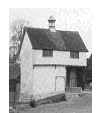
The village is noted for its medieval moated sites, particularly Down Hall, along a lane to the SW of the village, with a moat, water-mill, and ancient gatehouse. Radiocarbon analysis of the latter has given it a date-range 1250-1380. The gatehouse is jettied on two sides, and has two entrances, one for horseriders and one for foot-travellers. The bell-topped lantern is said to have acted as a guide for travellers across the moor. Down Hall Manor was in existence before the Conquest, in the hands of Alwyn, The King’s Crier. In the middle of the village is the pub, now called “The Pig & Abbot” (formerly “Derby & Joan”). The name changed when a village consortium bought the property, to save it from closure: the food is recommended.
There are 11 rights of way in the parish, giving reasonable access to Shingay, Steeple Morden and Litlington, but only laboriously directly to Bassingbourn across 5 arable fields (using Footpath 7, which starts up a field entrance between gardens, almost opposite the pub). Try this after harvest, or in Spring when the crops are short, or when the ground is frozen hard! Local soil is boulder clay, or chalk overlying clay.
Footpath No.8 leads from 62 High Street, at the road corner, down the gravel drive in front of the house and continuing SW as a grass path with wood to right and arable to left. By the corner of the wood, “Bibles Grove”, we pass out of the parish, but a good all-weather gravel track continues SW between fields to Steeple Morden.
For a very short circuit, turn off left at the corner of Bibles Grove, TL 301 440, and join the gravel track, bridleway 1, running towards Down Hall Farm, where the famous gatehouse may be inspected. From here, turn left (NE) to walk up the lane, passing a wood pleasant with primroses in Spring, and thence return to the village.
 Three longer options are possible from Down Hall Gateway.
Option (a): turn right, (S) towards the mill buildings, then turn SE over Cheney Water Mill Stream on a wide brick bridge and go through the wooded garden of the Mill Cottage, on Footpath 5, finally emerging over a shallow ditch into an arable field, TL 305 436. The continuing cross-field path in Litlington parish is often reinstated, and nearby paths through Manor Farm, Litlington lead to the centre of that village.
Option (b): continue past Mill Cottage on a grassy footpath (No.4) with Cheney Water to left. Follow this to TL 292 437 where a bridge spans the stream. Either cross the bridge and turn left for a good network of paths to Litlington or Steeple Morden, Or stay on the path to TL 296 435, where leave the field edge turning right across a narrow strip of arable field to join the firm bridleway to Bogs Gap, Steeple Morden. This route is reasonable in Winter, since the cross-field section is minimal.
Option (c): continue on Footpath 4, but turn off left on Footpath 6 at TL 302 435, crossing Cheney Water by a farm bridge. The RoW follows a mown grassy track with hedge & trees to right, arable field to left, to a waymark post at TL 302 434 by the field-corner where it turns SW to continue as Steeple Morden Footpath 22 across an arable field. (This option is not recommended in Winter, as the last field is very sticky!). Note that Footpath 6 was diverted in 1987, so older maps are incorrect.
Footpaths 2 & 3, leading to the N end of Steeple Morden, via Mill Hill, TL 301 440 need careful map reading, and involve some arable fields.
Footpath 2 turns off NW just beyond Bibles Grove, TL 301 440 on a track to Mill Hill. It turns left, right, and left again, sparsely waymarked, to the end of a hedge, TL 295 443, from whence it continues SW along a 2m wide earth track between open arable fields, crossing a bridge to continue in Steeple Morden, and emerge nearly opposite the grassy access lane to the new Woodland Trust Woods. There is a seat in the plantation – you might need to sit down after a couple of heavy fields! (At TL 295 443, Footpath 3 turns off right from Footpath 2, NW across the arable field, leading to a path which crosses paddocks, and emerges through the garden of a house on the corner of Flecks Lane.. )
Back in Abington Pigotts, follow the lane to the church, which has a porch dating from 1382. Bridleway 9 continues North beyond, as a pleasant wooded lane, muddy in Winter. Bridleway 10 is clearly signed, turning off left, and leading to Flecks Lane. This path is often heavily poached by horses. On Flecks Lane turn right, soon picking up a path on the right leading to Running Ditch, and thence to Shingay. A quiet narrow road leading SE will bring the walker to the signed turning for Footpath 11, first as a clear track across an arable field, then briefly along a field edge, before becoming a charming narrow trail through trees, and rejoining bridleway 9, making a circuit of ca. 3 miles from the church.
Points to Ponder…
Footpath News, Issue 25, April 2003 contains details of the largest estate in Britain with no rights of way. John Andrews, RA footpath worker in Suffolk, contends that this is the Shadwell Estate of 6000 acres, situated E of Thetford. It is owned by the royal house of Dubai, who breed racehorses there and also covers breckland and woodland. It seems that the pathless situation may be due to change with imminent publication by Norfolk County Council of Modification Orders for 2 byways, one of which connects with the Peddars Way. Access land claimed under the CROW Act may cause dispute..
Footpath News, Issue 30, Aug. 2003 reports on research into the economic value of walking, in a project on the value to the economy of England’s paths and access land.
Preliminary findings suggest –
- £5.78 billion is spent by walkers in the countryside;
- between £1.4 billion and £2.6 billion income is generated by walkers.
Translated into employment statistics, walking supports up to 231,360 full-time jobs.
I’m not sure how these figures were derived, but it sounds very impressive. How much do you spend on a day out walking?
- Cost of transport (train fare or petrol);
- Lunch out, or just a drink or ice-cream;
- Maps and guide book;
- Sun lotion, sting relief etc
- Wear & tear on equipment – I reckon it costs 20 pence every time I wear my boots!
RoSPA (Royal Society for the Prevention of Accidents), in its annual report, gave the following figures for walking-specific injuries.
- 1300 reported accidents were caused by stiles, and 2600 accidents attributed to barbed wire. Although barbed wire should not be found at access points on rights of way, much remains, or the nails from which the wire has been removed…
Cambridge Group in Cumbria
In early May, 11 walkers (some part-time) joined the RA Cambridge Group to Bassenthwaite for its sixth visit to Kiln Hill Barn. Once again, we enjoyed the hospitality of Ken & Heather Armstrong in the comfort of their lovely old farmhouse.
On the first day, 8 of us did a circuit from Greenhead, climbing the steep grass slopes of Yard Steel, and visiting Great & Little Scar Fell, some taking a deviationary route fording a stream, before re-uniting for tea at Uldale.
The second walk took us from Honister to Seatoller, over Dale Head, High Spy & Maiden Moor, a splendid ridge walk.
Day 3 took us to Buttermere, and up Haystacks via Scarth Gap. The next day was wet at first, so a lower woodland walk was planned from Whinlatter, through woods and by the shore of Bassenthwaite Lake back to the farm, only to prove the hottest day of the week! We had more typical damp weather for the last two days – just four souls and Nell, the dog, braved the rain for a circuit from Howtown onto Red Knott, while the wiser shopped in Keswick. The last day was memorable not just for the rain, but for blustery winds, which made the ascent of the modest Knott Rigg up Newlands Pass quite exciting, but we were finally rewarded for our persistance with acres of bluebells in Rannerdale in sunshine.
This was the sixth group trip to Bassenthwaite, and we think the last, having led some 36 walks without repetition, or travelling too far.. Thank you to all those who have joined us over this period – the time has come to seek a new venue, when we hope you will come with us again.
Janet & Roger
Cantab Rambler by E-Mail & Post
A large number of you now receive Cantab by e-mail. By hand, 10p is appreciated towards the cost of paper and ink. If you would like to receive an issue by post, please send a large SAE, and a 10p stamp.
Offers of brief articles will be gratefully received.
This is a privately produced magazine, and the views expressed are solely those of the editor, or of the author of an individual item. Janet Moreton 01223 356889
e-mail roger.janet@care4free.net
Price 10 pence where sold © Janet Moreton, 2003.
Comment Header
Comment Footer