Skip to content

Document Header

Content Header

CANTAB87 – December 2016

CANTAB87 – December 2016 published on

** Please note that this is an archive of the CANTAB publication and contains out-of-date information **

CANTAB RAMBLER

Pre-Christmas Issue!
Filled with enthusiasm for my subject, this issue is following closely on Cantab 86. So please read it now, before being overcome by seasonal preparations. Good wishes for Christmas & 2017.
Janet Moreton

After pits, moats!
Last month’s article on some old pits and quarries produced a prompt and enthusiastic response. Clearly, readers share my enthusiasm for old pits festooned with rampaging wild flowers and bushes, or sheets of water enlivened with wheeling flocks of birds.

Several people noted other pits which I had not mentioned, this being a matter of space. I could have included Coploe Hill old chalk pit maintained as a nature reserve off Coploe Rd (TL 493 426) above Ickleton, or a former chalk pit in Haslingfield, accessed by a short lane at TL 409 519, both noted for their wild flowers. In Anglesey Abbey grounds, the fish pond not far from the Mill, is described as an old quarry!

However, this issue I intend to move on to examples of another type of interesting ground features, moats. I emphasize the word, “examples”. A leaflet produced by the County Archaeology Dept, ca 1990, suggests there are 340 moats recorded in Cambridgeshire, moats being one of the commonest kinds of medieval remains in today’s landscape. The ones I have selected are primarily in South and East Cambridgeshire, and are visible to the walker, at least from a public footpath or a road. Most have some provenance.

Denny Moat, Swaffham Bulbeck
Explorer 226
Driving from Lode, one enters Swaffham Bulbeck at a bend in the main road. Here is some authorised parking at the corner of the extensive green, TL 555 628. Just at the edge of the car park is a display board, giving the history of Denny Moat, just behind it. In 1910, a Col. Hammond, of Mitchell Hall, sold Denny Close with an ancient 3 acre Elm Plantation to the parish council, who still own it. The woodland is now mixed, and most attractive, covering the moated area, about which one can wander at will on little paths (except in the wettest season, when the moats regain some water!). Denny Moat was linked to two double moats; it is not connected with the history of a former local family; nor is it thought to have surrounded a building

Elsewhere in Swaffham Bulbeck, in the period 1250 – 1350, there were also double moated enclosures, encircling manors at Burgh Hall, Lordship Farm, and Downing College Farm. In the short walk described below, on the footpath in front of Lordship Farm, note the curved linear depressions in front of the old farmhouse.

Leave Denny Moats, and walk across the green, towards Lordship Farm. A kissing gate gives access to a short path leading to Commercial End. Walk down this road towards the old Abbey. Between newer homes, are the old buildings reminding us of the prosperous waterborne trade in the period 1600 to the beginning of WWI. The old warehouses are now impressive residences. At a T-junction, TL 558 633, turn left along the tarmac lane towards Cow Bridge, and either continue on White Droveway, to join the main road back to Swaffham Bulbeck at TL 551 628, or use the footpath starting just beyond Cow Bridge. (2 miles).The walk can be linked to excursions from Anglesey Abbey, or with walks from Swaffham Prior.

Morden Hall, Guilden Morden
Explorer 208
The “Shell” guide says the plastered and many-gabled Morden Hall is one of the best preserved moated sites in the county. The house, off Trap Road, TL 280 437 was built after some destruction in the Peasants Revolt in 1381, and is set within an imposing and attractive moat still 10m wide, and waterfilled.

Parking for a few cars can be found outside the rec fence, opposite the church, TL 280 442. Cross the rec diagonally to a handgate, and walk SSE down the field boundary to a line of trees bordering the moat. Turn left alongside the tree belt, and cross a footbridge into “Tween Towns Wood”, a Woodland Trust reserve bordering part of the moat. Exit the same way, and find a handgate in the tree belt at TL 284 440. The path between fences crosses paddocks containing sheep, goats and sometimes alpacas. There is a good view of Morden Hall, especially in Winter. Emerge on Trap Road, and either turn right and walk back to the church, or make a longer walk using the huge number of signed paths in Guilden Morden.

Abington Pigotts’ Moats
Explorer 208
The Parish is notable for its medieval moated sites. Park in the village near “The Pig and Abbot” and explore. First visit the church (Norman origins, mostly C14th) and go past to the start of the brideway, to pass Manor Farmyard. The (partly) water-filled moat continues alongside the bridleway for some distance.

Originally known as Abington Manor, the property passed from the Bishop of Winchester to the Pigotts family. Described in a late C13th widow’s dowry, it had a fish pond, 6 acre moated site, a walled and moated enclosure and outbuildings. In C14th, the Pigotts built a second house, reusing another moated site N of the church. The house was re-modelled in the C17th, and is romantically gabled. From the church, go along the bridleway and turn left at TL 306 449, and follow the track to Moynes Wood. Here, Moynes Manor once stood in a double sub-rectangular moat, still preserved (but not exciting!). By 1381, this was already described as an empty moated plot of 12.5 acres.

Return directly to the pub (or make a 5 mile circuit via Flecks Lane, Running Ditch, past Shingay South Farm, and using the footpath starting NW of Boys Bridge).

From the pub, go SW down to the road corner, TL 306 443, where take the footpath WSW to Bibles Grove. At the end of the trees, turn left (SE) to Down Hall Farm. This moated site comprises 2 adjoining moated enclosures.

Many will already know the unusual timber-framed jettied gatehouse, at the entrance to the second enclosure, with timbers dating from 1250 to 1380. The existing farmhouse is C19th. (Do not go down the drive!). It is possible to continue a short distance to the signed former watermill (now a house), and to follow a footpath through the garden, giving access to a route to Litlington.

Kirtling Towers and Moat
Explorer 210
The greater part of Kirtling village is owned by the Fairhaven Estate, said to have existed before the 1086 Domesday survey. To visit the towers and moat, park in the village hall carpark (if not in use), pass the village sign, and walk up Saxon Street. Pause to admire both churches. The church of Our Lady and St Phillip (RC) was built 1877. All Saints (C of E) contains the family vault of the North Family, first owners of Kirtling Towers.

Take the footpath past All Saints generally E towards the Upend Road, giving good views of Kirtling Towers. In 1260 a Kirtling Castle was recorded. Later, within the castle’s platform, was built a brick Tudor house, bearing a date 1572. The occupied, turreted gatehouse is all that remains. A medieval moat, once the largest in the county, still surrounds the towers. Although some of it has been drained, the portions to the N & E of the building are still filled with a 60 – 70ft stretch of water. Return to the village sign and carpark. Other attractive routes in the vicinity include a circuit of Lucy Wood and beyond.

Dunmowes Moat, Fulbourn
Explorer 209
In the middle of Fulbourn Fen Nature Reserve is a fine moated site, enclosing the former Dunmowes Manor Hall House. The moat was built in the medieval period. It is 30 ft wide, and up to 10 ft deep, and would originally been deeper, and full of water. There is no entrance, so access to the site must have been by means of a wooden bridge. The moat encloses about an acre, now grass and trees, with fallen tree-trunks, a good place for a picnic. A large stone and timber house stood on the E side of the platform, with further buildings to the N and W. Stone mouldings and fragments of painted window glass were found, suggesting a high status house. Whilst the moat may originally have been defensive, in later times, a moat became a status symbol. Soon after 1750, the house was abandoned in favour of another site on School Lane, Fulbourn.

The site is easily accessible within the nature reserve, with an attractive display board.

Rampton: Giant’s Hill Moat
Explorer 210
The main archaeological attraction in Rampton is Giant’s Hill, the site of a castle started in the mid-C12th, when the throne was contested by Royal cousins, Stephen and Matilda. Meanwhile, Geoffrey de Mandeville, a rogue Essex baron, captured the Isle of Ely and sacked the monks at Ramsey. Stephen ordered a ring of castles to contain the threat. Burwell, Swavesey, Caxton Moats, and Giants Hill survive as known castle sites. Geoffrey de Mandeville was mortally wounded at Burwell, so the castles were never completed.

However, at Rampton there remains a splendid example of the unfinished fortification. The site’s rectangular platform is surrounded by a largely complete moat. The adjacent field shows grassy mounds of deserted house-sites.

The castle site, owned by the County Council, is accessible from a gate in the village, off the main road at TL 430 680, or from the grass field next to the ancient thatched church. A display board gives points of interest. The moat, still water-filled, can be crossed on a board walk, and all parts of the site explored. Later additions include a WWII gun emplacement sited by the Home Guard.

A short walk may be enjoyed on County Council land in woods behind the castle site, or extended to make a circuit along the bank of New Cut, Great North Fen Drove, Archies Bridge, and returning to Rampton along Cow Lane. (4 miles)

Haslingfield Moat
Explorer 209
A moated manor was built by the Scales family and occupied by them in C13th to C15th. In the C16th, Sir Thomas Wendy, physician to Elizabeth I, bought the property. By 1726, the manor was described as “ruinous”, and in 1814 two wings were demolished. The E wing, moat and walled garden remain. The site overlooks the Well Field, a recreation meadow in the centre of Haslingfield, off a lane behind the church. The field boasts a well house, a period bakery, and a replica earth closet. Haslingfield’s present manor’s 3-sided garden moat survives in good condition at the rear of the meadow, fronted by trees and bushes. A brook issues from the moat, fed by internal springs. The moat is, however, rather difficult to see, except in the NW corner of the meadow, where a sign says “Danger, deep water”.

Other points of interest in the locality are the unusual Millennium sundial, on the green, next to the village sign, which shows Elizabeth I on horseback, as when she visited Haslingfield in 1564. Only the chancel walls remain of the original Norman church, the later building having a notable C15th tower. The churchyard has a delightful short nature trail.

Letter to the Editor
‘I notice mentioned “Commissioners Pit,” which is an SSSI for two reasons. The chalk bank is a fossilised coral reef and the best preserved Oxfordian in Cambridge-shire. And also the bottom part of the area is part of The Cam Washes and hence an SSSI for Ornithological reasons. The County Council in its need to keep its coffers filled has sold the pit to a private buyer. I do not yet know who has bought it… But it may not be too late to buy it for the public. I don’t know if it has actually been sold.’
Duncan Mackay

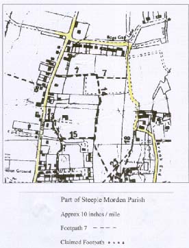
Steeple Morden Footpath 7
Can anyone help the Parish Council and the Ramblers’ Association to claim a section of well-used path as a definitive right of way? The length of path is sign-posted by the County Council, who are now threatening to take the sign away!

The path starts off Hay Street at TL 287 432, and runs to Brook End at TL 290 432. The section in question starts from a gap in the hedge, TL 288 432 and runs along field boundaries as a good grassy path to Brookside.

Please contact the editor.
Janet Moreton

Cantab Rambler by E-Mail & Post
Cantab usually appears about 4 times yearly. A large number of you now receive Cantab by e-mail. If you would like an issue by post, please send a large SAE. Offers of brief articles welcomed..

This is a privately produced magazine, and the views expressed are solely those of the editor, or of the author of an individual item.

Janet Moreton 01223 356889
e-mail roger.janet@outlook.com
Cantab87 © Janet Moreton, 2016.

CANTAB86 – October 2016

CANTAB86 – October 2016 published on

** Please note that this is an archive of the CANTAB publication and contains out-of-date information **

CANTAB RAMBLER

Network Rail’s Level Crossings
Ramblers are very concerned regarding plans by Network Rail to close or divert 130 level crossings in East Anglia, under the Transport and Works Act, 1992.

Some ten percent of these are in South and East Cambs. Taking advice from Ramblers London Office, Lisa Woodburn Chair of Cambridge Group, has made the Ramblers’ Case for South Cambs paths, and Alysoun Hodges the case for East Cambs crossings.

Additionally, Alysoun has discovered that Network Rail has closed Ely Footpaths 17 and 57 (which cross the railway line to Norwich, on either side of the River Lark) without following prescribed legal procedures. A Traffic Regulation Order (TRO) is said to be imminent, but had not been made by the end of September. Alysoun has complained about this unlawful closure to Cambridgeshire County Council, in its role as Highway Authority.

Pits and Holes
Cambridgeshire may be largely flat in a general way, but on a smaller scale, the countryside is enlivened by the presence of quite a number of pits and holes, ranging in size from small holes to huge lakes.

In times past, farmers dug lime pits in the middle of fields, to spread the contents on the land, to improve the tilth. This is the origin of the smallest holes, now often filled with water, and surrounded by a few attractive trees in the middle of a field.

Larger holes were due to quarrying on a larger scale, sometimes for building purposes very close at hand, such as the chalk blocks (clunch) taken to build the church at Orwell, from the adjacent pit, now a nature reserve. Commercial chalk pits, such as at Steeple Morden may still be operational, with public footpaths adjacent. Barrington Fp 11, along the top of a hill above the commercial chalk quarry needed to be legally re-aligned in 2005, because of anxieties regarding the safety of the edge of the quarry (which has now closed).

Quarrying for sand and gravel has been very common in Cambridgeshire, sometimes in the quite recent past, such as at Fen Drayton Lakes, now an important RSPB reserve, and sometimes ongoing. such as at Needingworth/ Overcote and Paxton Pits (both still in use for gravel extraction), and the new sand pit at Sawston. Worked-out commercial sand and gravel pits, which usually fill with water, have been developed as recreational amenities and environmental reserves, sometimes such a concluding phase being written into their planning permission.

In the C19th, shallow quarrying for coprolites occurred over a wide band, from Leighton Buzzard to Burwell, but only in a few cases do the signs of such activity remain. Copralite “cuts” (generally holes filled with water), are quite frequent in the Lode, Stow cum Quy and Horningsea localities.

The biggest “holes” filled with water to become reservoirs such as Graffham Water are not holes at all, but flooding of valleys by creating vast dams. Similarly, Cambourne lakes are of a different nature, as they are really balancing ponds, following the development of a now considerable built-up area. However, both these sites have evolved hand-in-hand with a network of new paths.

Accessible Parish pits (chalk), are to be found at Litlington, Guilden Morden, Harlton, Stapleford, Reach, Little Wilbraham, and elsewhere. The pit at Orwell was a source of superior chalk called “clunch” used as a building stone.

The object this month is to look at examples of “holes” which are publicly accessible, and add interest to a ramble. I certainly do not wish to encourage readers to investigate private or dangerous pits!

Examples of Large Sites
Paxton Pits
The Nature Reserve here operates alongside on-going sand and gravel extraction. The present reserve of 77 ha is set to expand to over 280ha “within the next decade”. Presently available paths include part of the Ouse Valley Way. Well marked routes comprise The Heron Trail (2 miles) and The Meadow Trail (1.5 miles). Attractions include riverside & meadow flora, and excellent birdwatching.

There is a bus service from St Neots to Little Paxton Village.
Facilities on the reserve include visitor centre, toilets, free car park, tea facilities (weekends, holidays), leaflets, and possible hire of motorised boggy for disabled usage. See: www.paxton-pits.org.uk

RSPB Fen Drayton Lakes
The RSPB reserve at Fen Drayton Lakes was established in 2007, with the purchase of a privately owned nature reserve, and some adjacent lakes and washland. The previous sand and gravel quarrying had left large deep lakes, sometimes with islands. Birdwatching has been possible here since the 1950s, and over 250 species of birds have been recorded.

There is an impressive network of public rights of way and permissive paths around the lakes, which are best accessed by guided bus from either Cambridge or St Ives. A walk of less than 2 miles along the Busway bridleway from St Ives to the reserve in Summer can reward the keen observer with a list of nearly 100 wildflower species. Also accessible from the lakes is the Ouse Valley Way.

Adjacent to the guided bus stop is a shelter and information point, with free leaflets available. Across the Busway is a free carpark, with WC, both accessible down a short drive. Please be reminded that both the bridleway beside the Guided Busway, and the paths in the reserve are liable to flooding in Winter, occasionally making access impossible. More RSPB info may be found at: www.rspb.org.uk

Milton Country Park
The site owes its present appearance to commercial extraction of sand and gravel for house construction and road building between ca 1930 and 1960. However, some 1800 years ago, part of the site had been used for extraction of clay by Romano- British potters! South Cambs District Council acquired the site in 1990, and by 1993 the country park was open to the public. The park is now managed by a commercial concern, with a charge for carparking. Café and WCs are available.

There is quite a complicated network of paths around the pits, and the walking can readily be extended along Fen Road, to join the River Cam towpath.

Examples of Smaller Sites
Guilden Morden
The parish has a typical chalk pit, originally for use of the villagers. It is attractive with wild flowers in Summer, and is best accessed from Ashwell, along Ashwell Street to TL 282 402, then turn SE down Guilden Morden Bp 51, turning left onto a field-edge track at TL 283 398. Pass a Countryside Access Scheme notice, and access the former chalk pit over a stile at TL 284 400, and down a ramp into a riot of shrubs, wildflowers and nettles. This is a place for solitude. A Romano-British cemetery was excavated near the chalk pit in the early C20th, but no signs remain.

The Three Cherry Hinton Pits
Lime Kiln Close Nature Reserve
This is one of three chalk pits available in the locality, accessed at TL 486 562. The reserve was a medieval chalk quarry, and much of the chalk was probably used to make lime mortar for houses in Cherry Hinton and Cambridge. Nature has taken time to reclaim this pit for trees and bushes, with secondary woodland of ash, field maple, and wild cherry.

West Pit, at TL 483 555 off Lime Kiln Hill is an SSSI and a more open habitat, full of wild flowers in Summer – and home to the rare moon carrot.

The newest and largest reserve , East Pit, off Lime Kiln Hill at TL 484 557 is an interesting expanse of bare chalk, rapidly being colonised with interesting flora, and has prehistoric remains, with good information boards.

Orwell Clunch Pit
The village website describes The Clunch Pit as an environmental treasure. The old quarry site of 1.6ha is accessible from High Street, by steps going up beside the church, or from the lane leading to the carpark. A public footpath leads to the top of the pit from the A 603. The Pit has been owned by the Parish Council since 1974, designated as an SSSI in 1985, in recognition of valuable chalk grassland flora and fauna. There was major scrub clearance in 1999, and the pit is now managed by light Summer grazing by sheep, and an annual cutting of brambles.

Coprolite Diggings
Coprolite is the name given to fossilised bones of dinosaurs, found in bands of the chalk belt running across Cambridgeshire and beyond. These deposits were generally rich in inorganic phosphates, a valuable source of fertiliser, before the establishment of modern chemical industries.

The C19th technique of open cast or shallow-pit mining for coprolite generally left land fairly level. The diggings at Parkers Piece have left no trace, although the bumps on Coldham’s Common may well be poor restoration after mining.

In Lode and Stow cum Quy, however, there are some actual water-filled pits, in a pleasant situation. From Lode village by the Millpond, take a footpath N to cross the track of the old railway at TL 530 629, then go E on the wide Lode Byway 15, which continues as a footpath across a field to the waterfilled pit set attractively in trees at TL 521 627. Continue along the path and over a footbridge onto Stow cum Quy Fen, and cross the grass towards the next pit at TL 515 626. This has interesting Spring plants, including the scarce water violet. Exit W, picking up Horningsea Bp 8, with useful parking at TL 498 630.

Steeple Morden Chalk Pit
Here, one can appreciate the effects of quarrying in the making. The Steeple Morden chalk pit has paths going round its perimeter, and one can actually cross a little footbridge over the conveyor belt. The chalk is very pure, and used in applications like pharmaceutical products, toothpaste, and as a filler in car tyres!

From Ashwell Street at Upper Gatley, TL 295 409, take Fp 42 going roughly S uphill. At TL 298 405, fp 42 turns off right, round the bushes at the edge of an arable field. At the field corner, TL 296 404, the path enters the edge of the wood containing the chalk quarry. The path continues round the wood, passing buildings, and crossing a conveyor belt on a bridge and the quarry access road at TL 295 401. Fp 42 exits down the quarry road, but follow fp 43 ahead, still round the edge of the quarry. At TL 300 400, go through a clear gap in the wood, and return N to Ashwell Street on Fp 47, with the wood on the left.

There is a high density of paths in this area, and a longer walk would prove rewarding. There is another large chalk pit near Ashwell & Morden station at Odsey.

Commissioners Pit, near Wicken Fen
This fenland pit is typical of the depressions left following embankment of the nearby fen lodes.

It is best approached from the pub near Upware, “Five Miles from Anywhere, No Hurry”. From the drive to the pub, find the signposted footpath over a bridge and stile, running N through low lying fields. Later, the path bends right and left, and joins a hedged track (Fodder Fen Drove) which passes Commissioners Pit Nature reserve. Descend a flight of steps into the reserve. There is a display board. In 1998, in the unstable bank of the reserve, after rain, I found a bivalve fossil and a fossil scallop, which were identified by my evening class tutor as being from the Jurassic period, 200 Million years old.

Harlton Chalk Pit
This delightful, wooded pit is owned by the Parish Council, which allows free access. Go up Fp 4, which starts at TL 389 523. This wooded lane leads up to the base of the pit. Fp 4 is waymarked through the pit, which has a mostly bare chalk floor, and whose slopes can be very slippery after rain. Ascend by one of a number of trodden routes. The steepest ways are to the left. The longer, easier routes are found by first bearing right. In 2000, the definitive line of Fp 4 was extended to the top of the pit at TL 391 520, from whence a narrow wooded path leads through spurge laurel bushes to join Barrington Fp11 along the top of chapel hill. From here, it is possible to look down on the huge, recently closed commercial chalk pit behind Barrington.

Litlington Chalk Pit
A description of this pit is included as a reminder that not all old pits are attractive. From Royston Road at TL 318 419, a grassy lane, Byway 11, runs WSW from locked gates, with access space each side. The track runs to a patch of open downland, with the remains of an old pit beyond. The right of way terminates at TL 316 417 but regular access continues over a wider area. The pit is also accessible from Ashwell Street. When last seen, it contained some dumped material.
Janet Moreton

Cantab Rambler by E-Mail & Post
Cantab usually appears irregularly about 4 times a year. A large number of you now receive Cantab by e-mail. By hand, 10p is appreciated towards the cost of paper and ink. If you would like to receive an issue by post, please send a large SAE. Offers of brief articles will be gratefully received.

This is a privately produced magazine, and the views expressed are solely those of the editor, or of the author of an individual item.

Janet Moreton 01223 356889
e-mail roger.janet@outlook.com
Cantab86 © Janet Moreton, 2016.

CANTAB85 – June 2016

CANTAB85 – June 2016 published on

** Please note that this is an archive of the CANTAB publication and contains out-of-date information **

CANTAB RAMBLER

Focus on Royston, Herts
Royston’s adjacent common, Therfield Heath, is a wonderful open space, with free parking, or easy access from Royston Station. The Heath gives immediate access to the hills beyond, higher than anything in Cambs! Before you go tramping off on these hills to Therfield, Sandon, Kelshall, Barley, Barkway and places beyond, pause to appreciate the riches of Royston.

Around Easter, the nature reserve at the east end of the Heath is well-known for its display of the Pasque flower, the Anemone pulsatilla, together with cowslips and violets, on an isolated spur of bare hillside. White heleborines may be seen in the adjacent woods in May.

Later in the Summer, the main part of the heath is a treasure trove of wild flowers, especially at the west end, in the little dry valleys.

Alfred Kingston wrote a monograph, “The Heath and its Wild Flowers” published originally in 1904, but reprinted by Warren Bros. and Cooke Ltd in 1961. By 1904, the Royston Golf Club had already been formed using part of the Heath in 1892, and had erected “a handsome and commodious club house on the corner nearest the town”, and a public pavilion, near the cricket ground opened by public subscription in 1895. *[See also Cantab 17 – Royston 1900: A year in the life of a small town.]

Kingston lists the flowers which could be seen between June and August, an impressive list, now sadly reduced, so that, for example, I do not think we would now find two of the orchids he quotes – Gymnadenia conopsea (fragrant orchid) or Orchis ustulata (burnt orchid), but Ophris apifera (bee orchids) pop up occasionally in all sorts of places.

Nor has the ground-nesting stone curlew survived the invasion of hundreds of walkers, golfers, kitefliers and dog enthusiasts, but instead we have a fair chance of seeing feathered red kites!

From Kingston’s list of 1904, and with some modern additions, I produce here a restricted list which Roger and I identified on the Heath last Summer, and which might act as an aid to identification, in conjunction with a field guide.

Agrimony (yellow)
Birds-foot trefoil (yellow, touch of red)
Bladder campion (white)
Burnet saxifrage (brown & white)
Candy-tuft (white)
Cathartic flax (white)
Centuary (pink)
Clustered bellflower (deep blue)
Dropwort (white, pale pink)
Forgetmenot (blue)
Greater celandine (yellow)
Ground thistle (purple)
Germander speedwell (bright blue)
Hairbell (pale blue)
Mouse-ear hawkweed (lemon yellow)
Heath spotted orchid (spotted leaves)
Horse-shoe vetch (yellow)
Jack by the hedge (white)
Kidney vetch (yellow)
Ladies bedstraw (yellow)
Milkwort (blue or mauve, purple)
Meadow rue (pale yellow)
Mignonette (cream)
Musk thistle (purple, nodding)
Rock rose (yellow)
Rose madder (pink, very small)
Silver weed (yellow, silver leaves)
Small scabious (lilac)
Squinancywort (mauve or white)
Tall broomrape (brown)
Toadflax (yellow & orange)
Viper’s bugloss (blue & pink)
Welted thistle (purple)
Wild thyme (light purple)
White and red campions
Yellow-wort (yellow!)

Later in the Summer flower:
Autumn Fellwort (purple)
Blackberry
Carline thistle
Meadow Sweet
Rosebay willow herb
Wild chicory

Ramblers sometimes say to us, “How do you know what flowers to expect here?” Perhaps this will help! This is not a comprehensive list and we have not included the common “weeds” of the daisy, dandelion variety. See if you can do better!

Visible Prehistory
As well as being a valuable wildlife haven, the Heath is an important prehistoric site. The oldest feature is a Neolithic long barrow, 6000 years old. Looking north from the long barrow, one can see the route of the Icknield Way, an ancient trade route from the Norfolk coast to SW England. The Heath’s high ground also attracted Bronze Age burials, here as One Hill, Two Hills and Five Hills. The features known as Mile Ditches (parallel to the Therfield Road) are Iron Age, and were probably territorial boundaries.

If the weather turns wet, Royston has inner resources.

The Royston Cave, a bell-shaped chamber cut into the subterranean chalk is unique in Britain. It contains numbers of carvings and symbols, whose origins are uncertain, although it has been claimed to have been associated with the Knights Templar, before their dissolution in 1312. The cave is located in Katherine’s Yard off Melbourn St, near the cross roads in the middle of the town.

The cave is open to visitors by guided tour, 2.30-5pm, Sat, Sun, Bank Holidays between 26 March and 25 Sept, and also Wed in August. Adults £5, Seniors £4.

Royston Museum
The original museum in the town hall, was opened in 1856, but was re-established in 1984 in the Old Congregational Church School, off Lower King Street. There are extensive local archives, pictures, archaeological finds, interpretations of Royston Cave, The Royston tapestry, and much else.

The museum is open all year, 10 – 4.45 pm, Wed, Thu and Sat, and also 2 – 4.45 Sun, Easter – 30 Sept. Admission gratis. Donations appreciated.

The parish church is set in attractive municipal gardens in the town. It is part of the old Norman priory, with a Victorian chancel.

Long Distance Paths
Royston is, of course, a hub of Long Distance Paths.

The Icknield Way Path is a 110mile trail, linking the Ridgeway Path to the Peddars Way. Together these routes take strands of the ancient Icknield Way trade route which crossed England from Norfolk to Dorset. Royston lies squarely on the route of this popular path. We have the 5th edition of the walkers’ guide, obtainable from the Icknield Way Association. See: www.icknieldwaypath.co.uk

The next long distance path is an unusual one. The Hertfordshire Chain Walk consists of 15 linked circular walks through rural East Hertfordshire, and published for the East Herts Footpath Society . The edition we have was published by Castlemead publications, Ware. The route passes through Therfield, narrowly skirting Royston! See:www.easthertsfootpathsociety.org.uk

The Hertfordshire Way is a magnificent 166 mile route, covering, as the name suggests, most of the County. This was very much a Royston walkers’ initiative, with the first section or “leg” going from Royston to Wallington. The guidebook, edited by Bert Richardson of RA Royston Group, is published for the Friends of the Hertfordshire Way by Castlemead publications. See: www.fhw.org.uk
Janet & Roger Moreton

Mill Road Cemetery, Cambridge
Nick Ballard writes in praise of our city cemetery in the RSPB magazine. Mill Road is “a closed cemetery, with no burials since 1955. Over eight acres harbour a surprising variety of animals and plants. My species list includes more than 110 plants and grasses (excluding trees and shrubs); 42 birds; at least 9 mammals including two species of bat, weasel and dormouse; 23 species of butterfly and plenty of lichens and other diptera. The Diocese of Ely must be praised for their management, along with the Friends Group which promotes the value of the site.”

The main entrance is off Mill Road, opposite the “Sally Ann” charity shop, and using all the paths, it is possible to make a walk of nearly a mile. Alternatively, one can make a short cut to Gwydir Street or Norfolk Street.

Essex Coast Path
The entire length of the Essex Coast Path has been opened, making the longest coastal walk in an English County, including large numbers of creeks and estuaries.

Essex RA are justly proud of their new path, and announced the imminent official opening in the September edition of the Essex Area Update. Peter Caton has written a book, “Essex Coast Walk”, available on Amazon. Maps and photos illustrate the text with details of ports, towns and villages along the route, nature reserves and points of interest, as well as the history of the coast.

Watching our words! A Footpath:
What do we mean by a Footpath?
In Britain, a footpath –
is a path for people to walk along,
is a walkers’ path, especially in the countryside,
is a narrow path for walkers only,
is a path for pedestrians alongside a road,
is a pavement,
is a term in geology meaning a horizontal expanse of bare rock or cemented pieces.

When using the term “footpath”, perhaps we should watch our step!

Try “Footway” for a made-up path alongside a road. “Public Footpath” or “Public Right of Way” (PROW) for a countryside path. However, “PROW” does not define the usage of the way – it needs to be qualified as a footpath, bridleway, byway, cycleway, road or whatever. And a road may be private, and yet have public footpath rights.

The term “pavement” is also fraught with difficulty. A pavement is a surface that is paved over. Pavements are part of the Highway. When they run alongside a county road, they do not have any separate legal existence.

A highway engineer regards the term “pavement” as referring to the whole paved area, so the footway alongside may or may not be classed as pavement depending on whether it is surfaced.

Finally, use “Sidewalk” for a footway if you go to the USA!

Letter to the Editor, County Summits. (See Cantab 84)
“Hello Janet & Roger.
Back in 2001 there was an article in the Cambridge Evening News about the highest village in the county, which they gave as Great and Little Chishill equal at 475ft. This provoked several items of correspondence and I wrote saying Great Chishill was highest, but didn’t know exactly where, but thought it was off any road. I then consulted OS who eventually came back with the very accurate grid reference of TL 42738 38546 and a map with a nice star in the middle of a road. This turned out to be Hall Lane Great Chishill.

Just a few months later I obtained the book ECHOES which was published in 2000 and describes walks to all of the county summits in the country. In that book several of the local summits are different from those you have quoted from Paddy Dillon’s book.. In the acknowledgements the author thanks the OS for their support of the project, so presumably they supplied heights and references. It seems to me that over the years OS have revised heights as they are able to use more sophisticated methods of surveying.”
John & Tessa Capes, 23 Feb. 2016

Hoffer Brook project
South Cambs District magazine describes improvements made to the Hoffer Brook between Foxton and Newton, where it runs beside a public footpath. Fallen trees have been cleared, and tree thinning and scrub clearance will let in more light. The water quality is good, and a fish survey is being mounted. It is hoped the brook will in future be less prone to flooding.
The first phase of the work on the brook was funded through the Cam and Ely Ouse Catchment Partnership, and a band of volunteers teamed up with the Wildlife Trust. The local landowners, Richard Barnes of Foxton and David Watson of Thriplow Farms helped with machinery and access for the works.

Cantab Rambler by E-Mail & Post
Cantab usually appears some 4 times per annum.. A large number of you now receive Cantab by e-mail. By hand, 20p is appreciated towards the cost of paper and ink. If you would like to receive an issue by post, please send a large SAE. Offers of brief articles will be gratefully received.

This is a privately produced magazine, and the views expressed are solely those of the editor, or of the author of an individual item.

Janet Moreton 01223 356889
e-mail roger.janet@outlook.com
Cantab85 © Janet Moreton, 2016.

CANTAB84 – March 2016

CANTAB84 – March 2016 published on

** Please note that this is an archive of the CANTAB publication and contains out-of-date information **

CANTAB RAMBLER

Why not Sawston?
Cantab Rambler goes back to 1999, and a majority of issues include a “Parish of the Month”, as I have been told this is a popular feature.

So why not Sawston – the biggest village in terms of population (but not, in land area, the biggest parish) in South Cambs? It is because I have been daunted by the task of describing the many inner village paths through the housing, and partly because I felt that many readers will know Sawston very well already. However, I hope the following may be of interest, and contain something new for you.
Janet Moreton
N.B. You can look up a previous “parish of the month” under cantab-rambler, on Cambridge RA Group’s website,
Cambridgeramblers.org/cantab-rambler/

Parish of the Month – Sawston
Sawston is quite a small parish of 770 ha. Most of the parish is situated on fairly flat chalk soils to the east of the bypass, which separates it from its water meadows by the R Cam, and Whittlesford beyond. The village, however, is the largest old-established parish in South Cambs [Cambourne looks set to have a population of around 10 000, but it does comprise 3 villages!], with a shopping centre and facilities sufficiently large and varied to accord it the status of a small town.

Like most of the villages of the Cam valley, there are traces of prehistoric settlement. A Neolithic flint axe was found S of the village, and signs of Neolithic tool production were found on the site of the old vicarage. At least 10 ring ditches, former Bronze Age barrows, are grouped around a former trackway, and a Bronze Age hoard (axes and spears) was found on the Icknield Way. Borough Hill Iron Age fort was located on the W side of the railway, near the present Spicers Works (ca TL472494, not accessible).

The Romans left few traces here. The parish was settled by the Saxons in the C7th, when agricultural patterns were established. An Anglo Saxon burial was found in 1816, when workmen dug gravel from Huckeridge Hill, ca. TL 481503 on the road to Cambridge, finding a sword, a bronze bowl and snake’s head buckle. An Anglo Saxon mill existed at Dernford.

In early times, the places where the river could be forded gave rise to scattered settlements along these routes. The manors of Dernford, Pyratts (on the site of Sawston Hall), and Huntingdon are recorded throughout the Middle Ages. Later in the Middle Ages, the N-S route, on the road between Cambridge and Royston became more important than the E-W routes, with the village cross marking the junction with Church Lane, at TL487492. Linear development occurred along the High Street, consolidated in the C13th, when Pirot, the lord of the manor, planned a village extension in the direction of Cambridge.

As early as C17th, paper making started at Dernford Mill, although a mill had been present here since 956. In the C19th, Towgood had a paper mill, and built homes for his workers. Spicer Brothers purchased the paper mill in 1917.

A Chamois leather works at TL 486489 was established by Hutchings & Harding in the. mid C18th, with later premises dating from the mid C19th. T S Evans of Old Yard Leather Works developed The Spike for housing at the S end of the village. Crampton’s Mineral Waters was another large employer. Thus, by the mid C19th, aided by the coming of the railway, and the introduction of steam power in the paper industry, Sawston was an industrial village, putting behind the poverty of the earlier part of the century, when at times up to a third of the population had been on poor relief following agricultural inclosure in 1802.

Domesday records 3 manors, and a population of 41. The census of 2011 recorded some 7145 residents.

Points of interest
The parish church of St Mary The Virgin is a Norman foundation, dating from the early C12th. Its tower is 600y old, and the nave arches are Norman and Early English. It is usually open.

Nearby are the locked gates of Sawston Hall, unfortunately not open to the public. The hall, the former seat of the Huddleston family for more than 400y, briefly sheltered Mary Tudor in 1553, but was burnt by the mob after her escape. Some of the original building remains. Stone from Cambridge Castle was used in the rebuilding, which is dated in the central quadrangle 1557 and 1584.

Notable old buildings in the village are C16th Ward’s House, and Huntingdon house (typical H-plan manor with cross-wings), and a manorial dovecote in Hammonds Rd.

Sites of Special Scientific Interest
One SSSI lies to the W of the bypass and up to the railway line, being one of few remaining areas of fen carr in the S of Cambridgeshire. The other is Sawston Hall meadows (both inaccessible).

Public Footpaths
Fp1 – Dernford Rd to Lt Shelford boundary
Fp2 – Cambridge Rd to Dernford Rd (fp1)
Fp3 – Hillside to Martindale Way
Fp4 – Baulks (High St) to Crampton Terrace
Fp5 – New Rd to The Baulks
Fp6 – Mill Lane to Common Lane
Fp7 – Mill Lane to join fp 6
Fp8 – The Bull, High St to Common Lane
Fp9 – High St to Whittlesford
Fp10- Catleys Walk, London Rd to fp9
Fp11- Babraham Rd to Church Lane
Fp12- Church Lane by Mile Path to Babraham
Fp13-The Green Rd to Sunderlands Corner
Fp14- Church Lane to Pampisford fp 2
Fp15- Mill Lane rail crossing to Whittlesford
Fp16 No 11 Church Lane to Churchfield Ave
Fp17- High St to Shingay Lane
Fp18- Chestnuts, Mill Lane to The Baulks
Fp19- Mill Lane to West Moor Ave.
Fp20- The Baulks from Crampton Terrace to Mill Lane (continues fp 4)
Fp21- Paddock Way to fp 11
A street plan is essential for following the inner-village paths. Without one, I have become misplaced on more than one occasion in the large housing estates!

Outline walks
Here are a few suggested walks, probably well known already to local readers, taking one outside the village envelope, and with ideas for further extension. They mostly involve a certain amount of road walking, and are thus more suitable for the muddy winter months, which commonly extend into April. I would suggest that an exploration of some of the inner village paths, using a good street plan, is also interesting and worthwhile.

A To Whittlesford & beyond 3, 6 or 10miles
From Sawston carpark (CP) TL 487494, go S down London Rd. Turn off R down signed fp 9, or shortly after along Catleys Walk (fp10). Cross the bypass and the railway, and enter Whittlesford past the Hamilton Kerr Institute (restorations for the Fitzwilliam museum). Cross the large rec towards Whittlesford Churchyard (approached via a residential road, to the R of the pavilion) to use Whittlesford fp 1, becoming Sawston fp15 over a footbridge, cross the railway on the road by Spicers barrier, and then the bypass. Find a “backs of gardens” route, fp 20, leading to the Baulks and so to High St and the CP. This route may readily be extended to include a walk around Whittlesford and the Moor (6 miles), or also paths to Thriplow (10 miles).

B To Dernford and Whittlesford 5 miles
This rather “roady” route takes in the historic Dernford Hamlet. From the CP walk NW up Huckeridge Hill along the footway of Cambridge Rd. Turn left on signed fp 2 (past a flock of sheep?) to the bypass. Cross with care and follow the signed path to Dernford, two arable fields to be negotiated en route. At Dernford House, the path is waymarked through the garden. The start of the continuing Lt Shelford fp 2 is sometimes very damp. Reach the road at Rectory Fm, and turn S on the road to Whittlesford, passing attractive lakes (but take care, no footway). It is a pity there is no route through Spicers land. At TL 466486, take the path SSW then SE through a pretty young plantation on access land in the centre of Whittlesford. On reaching the road, turn left and walk to Whittlesford Guildhall. A snicket at TL 473485 leads to Whittlesford church (usually open via door at rear, also WC). Return by the route described in Walk A.

C To Babraham, 4, 5 or 7miles
From the Sawston CP walk to the parish church, go down Church Lane, and follow “the green road” to across the rec. Cross Babraham Rd, turn R and take a signed path L, Babraham fp 11 to Rowley Lane. Turn R along the lane and follow it to the S end of Babraham. Return immediately on a new /footway cycleway (adjacent to Sawston Rd), or, from the road corner, take a crossfield path to join Sawston fp 12, Mile Rd. (4 miles)

However, from the wall at the S corner of Babraham, it may be desired to walk to the “George” PH for refreshments, and, on the return, visit the “Pocket Park” and the signed route to the Church, in a handsome rural position against the backdrop of Babraham Hall. (total 5 miles)

To extend this route yet further, continue on the path by the R Cam past Babraham Hall, and research buildings and across fields and tree belts, passing a turning R across a footbridge to a path to the A1307. However continue ahead to a substantial bridle bridge marking the next crossing of the Cam. Note the mounting blocks here, following the conversion of Rowley Lane to a bridleway. Turn round here, and walk back down Rowley Lane to join the return route. (total 7 miles)

D To Pampisford 4 miles
From Sawston CP, walk to the parish church, take Church Lane, and turn half right on fp 14, joining Pampisford fp 2 to Pampisford Wych. Go S down this road (no footway), and turn off R on a signed fp through Home Fm. In Pampisford, take a short cut across the rec and visit the church. Follow the road through the village, to the pub on the corner. Turn R along London Road, taking a detour, if desired, to the L, through the yard of the Black Bull, and continuing on fp 6 along the edge of a sports field, before turning R for High St. This walk is not readily extended, except by making various detours on Sawston inner-village paths.

East Anglian County Summits
Here is a suggested project for the Spring
Why not visit the East Anglian County Summits?
Cambridgeshire’s Top, at 146m, is located S of The Hall, Great Chishill, on Landranger 154, TL 427380. From the B1039, a track runs close to the site.
The Top for Essex, 140m is nearby, at TL 433362 in Great Chishill.
Norfolk’s County Top, 102m, is at the accessible Roman Camp, Landranger 133, TG 185415, near Sherringham.
Look for Suffolk’s Top, 128m, off the A143, at Depden, SE of Elm’s Farm. There is no trig point – a GPS might suggest the exact place, (Landranger 155, TL 786558).
Bedfordshire’s Top, 243m, is on the Dunstable Downs, about a mile out of Bedford off the B4541, Landranger 166, SP 008194.
Finally, the highest of them all, the Top for Hertfordshire, 244m is at SP 914091 on Landranger 165 off a minor road 0.5km W of Hastoe, in the Chilterns.
Data from “The County Tops”, Paddy Dillon, 1985.

Cambridge Weather 2015
The Botanic Gardens issued a report of last year’s weather, summarised below.

The year started with some instances of light snow, which quickly disappeared. Rainfall for March, April and June was below average, and there was evidence of the ground cracking on warm days in April. July was a month of extremes, when 35.0degC was recorded on 1 July, and storms brought 87.1mm rain overnight on 23 July, contributing to an unusually high month’s total of 153mm. Numbers of days of high winds occurred, which resulted in temporary closure of the garden. The year finished with a rainfall total of 556mm, almost exactly the average annual rainfall of 557mm.

Elsworth Footpath 2
Problems have arisen recently relating to path usage on and around Elsworth Footpath 2. The path is signed alongside the village school, TL 313637. It passes down a fenced passage, goes round the edge of a small field, over a couple of small bridges, and then goes generally NW towards Pitt Dene Farm. The problem is on this latter section. Walkers have used the available farm track, whereas in fact the right of way follows the field edge on the other side of the ditch, before lighting off across the fields near the site of some former pits. Fairly recently the landowner has taken steps to inhibit the use of the farm track. Do you know this path? Have you walked along the farm track, believing it to be a right of way? RA Cambridge Group have offered to help Elsworth Parish Council assemble some evidence of past usage. Please send any details to me,
Janet – roger.janet@outlook.com

The Bike-Bus Explorer, Cambridge to Gamlingay on Sundays
Just before going to press, I have heard a rumour that the Bike-Bus Explorer, mentioned in the last issue, is presently discontinued. Please check before making plans to use it.

Cantab Rambler by E-Mail & Post
Cantab usually appears some 4 times per annum.. A large number of you now receive Cantab by e-mail. By hand, 20p is appreciated towards the cost of paper and ink. If you would like to receive an issue by post, please send a large SAE. Offers of brief articles will be gratefully received.

This is a privately produced magazine, and the views expressed are solely those of the editor, or of the author of an individual item.

Janet Moreton 01223 356889
e-mail roger.janet@outlook.com
Cantab84 © Janet Moreton, 2016.