Skip to content

Document Header

Content Header

CANTAB84 – March 2016

CANTAB84 – March 2016 published on

** Please note that this is an archive of the CANTAB publication and contains out-of-date information **

CANTAB RAMBLER

Why not Sawston?
Cantab Rambler goes back to 1999, and a majority of issues include a “Parish of the Month”, as I have been told this is a popular feature.

So why not Sawston – the biggest village in terms of population (but not, in land area, the biggest parish) in South Cambs? It is because I have been daunted by the task of describing the many inner village paths through the housing, and partly because I felt that many readers will know Sawston very well already. However, I hope the following may be of interest, and contain something new for you.
Janet Moreton
N.B. You can look up a previous “parish of the month” under cantab-rambler, on Cambridge RA Group’s website,
Cambridgeramblers.org/cantab-rambler/

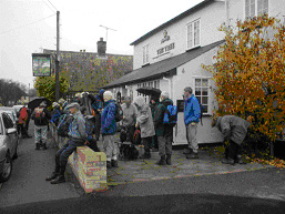
Parish of the Month – Sawston
Sawston is quite a small parish of 770 ha. Most of the parish is situated on fairly flat chalk soils to the east of the bypass, which separates it from its water meadows by the R Cam, and Whittlesford beyond. The village, however, is the largest old-established parish in South Cambs [Cambourne looks set to have a population of around 10 000, but it does comprise 3 villages!], with a shopping centre and facilities sufficiently large and varied to accord it the status of a small town.

Like most of the villages of the Cam valley, there are traces of prehistoric settlement. A Neolithic flint axe was found S of the village, and signs of Neolithic tool production were found on the site of the old vicarage. At least 10 ring ditches, former Bronze Age barrows, are grouped around a former trackway, and a Bronze Age hoard (axes and spears) was found on the Icknield Way. Borough Hill Iron Age fort was located on the W side of the railway, near the present Spicers Works (ca TL472494, not accessible).

The Romans left few traces here. The parish was settled by the Saxons in the C7th, when agricultural patterns were established. An Anglo Saxon burial was found in 1816, when workmen dug gravel from Huckeridge Hill, ca. TL 481503 on the road to Cambridge, finding a sword, a bronze bowl and snake’s head buckle. An Anglo Saxon mill existed at Dernford.

In early times, the places where the river could be forded gave rise to scattered settlements along these routes. The manors of Dernford, Pyratts (on the site of Sawston Hall), and Huntingdon are recorded throughout the Middle Ages. Later in the Middle Ages, the N-S route, on the road between Cambridge and Royston became more important than the E-W routes, with the village cross marking the junction with Church Lane, at TL487492. Linear development occurred along the High Street, consolidated in the C13th, when Pirot, the lord of the manor, planned a village extension in the direction of Cambridge.

As early as C17th, paper making started at Dernford Mill, although a mill had been present here since 956. In the C19th, Towgood had a paper mill, and built homes for his workers. Spicer Brothers purchased the paper mill in 1917.

A Chamois leather works at TL 486489 was established by Hutchings & Harding in the. mid C18th, with later premises dating from the mid C19th. T S Evans of Old Yard Leather Works developed The Spike for housing at the S end of the village. Crampton’s Mineral Waters was another large employer. Thus, by the mid C19th, aided by the coming of the railway, and the introduction of steam power in the paper industry, Sawston was an industrial village, putting behind the poverty of the earlier part of the century, when at times up to a third of the population had been on poor relief following agricultural inclosure in 1802.

Domesday records 3 manors, and a population of 41. The census of 2011 recorded some 7145 residents.

Points of interest
The parish church of St Mary The Virgin is a Norman foundation, dating from the early C12th. Its tower is 600y old, and the nave arches are Norman and Early English. It is usually open.

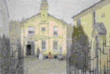
Nearby are the locked gates of Sawston Hall, unfortunately not open to the public. The hall, the former seat of the Huddleston family for more than 400y, briefly sheltered Mary Tudor in 1553, but was burnt by the mob after her escape. Some of the original building remains. Stone from Cambridge Castle was used in the rebuilding, which is dated in the central quadrangle 1557 and 1584.

Notable old buildings in the village are C16th Ward’s House, and Huntingdon house (typical H-plan manor with cross-wings), and a manorial dovecote in Hammonds Rd.

Sites of Special Scientific Interest
One SSSI lies to the W of the bypass and up to the railway line, being one of few remaining areas of fen carr in the S of Cambridgeshire. The other is Sawston Hall meadows (both inaccessible).

Public Footpaths
Fp1 – Dernford Rd to Lt Shelford boundary
Fp2 – Cambridge Rd to Dernford Rd (fp1)
Fp3 – Hillside to Martindale Way
Fp4 – Baulks (High St) to Crampton Terrace
Fp5 – New Rd to The Baulks
Fp6 – Mill Lane to Common Lane
Fp7 – Mill Lane to join fp 6
Fp8 – The Bull, High St to Common Lane
Fp9 – High St to Whittlesford
Fp10- Catleys Walk, London Rd to fp9
Fp11- Babraham Rd to Church Lane
Fp12- Church Lane by Mile Path to Babraham
Fp13-The Green Rd to Sunderlands Corner
Fp14- Church Lane to Pampisford fp 2
Fp15- Mill Lane rail crossing to Whittlesford
Fp16 No 11 Church Lane to Churchfield Ave
Fp17- High St to Shingay Lane
Fp18- Chestnuts, Mill Lane to The Baulks
Fp19- Mill Lane to West Moor Ave.
Fp20- The Baulks from Crampton Terrace to Mill Lane (continues fp 4)
Fp21- Paddock Way to fp 11
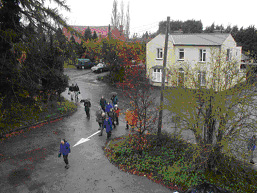
A street plan is essential for following the inner-village paths. Without one, I have become misplaced on more than one occasion in the large housing estates!

Outline walks
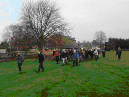
Here are a few suggested walks, probably well known already to local readers, taking one outside the village envelope, and with ideas for further extension. They mostly involve a certain amount of road walking, and are thus more suitable for the muddy winter months, which commonly extend into April. I would suggest that an exploration of some of the inner village paths, using a good street plan, is also interesting and worthwhile.

A To Whittlesford & beyond 3, 6 or 10miles
From Sawston carpark (CP) TL 487494, go S down London Rd. Turn off R down signed fp 9, or shortly after along Catleys Walk (fp10). Cross the bypass and the railway, and enter Whittlesford past the Hamilton Kerr Institute (restorations for the Fitzwilliam museum). Cross the large rec towards Whittlesford Churchyard (approached via a residential road, to the R of the pavilion) to use Whittlesford fp 1, becoming Sawston fp15 over a footbridge, cross the railway on the road by Spicers barrier, and then the bypass. Find a “backs of gardens” route, fp 20, leading to the Baulks and so to High St and the CP. This route may readily be extended to include a walk around Whittlesford and the Moor (6 miles), or also paths to Thriplow (10 miles).

B To Dernford and Whittlesford 5 miles
This rather “roady” route takes in the historic Dernford Hamlet. From the CP walk NW up Huckeridge Hill along the footway of Cambridge Rd. Turn left on signed fp 2 (past a flock of sheep?) to the bypass. Cross with care and follow the signed path to Dernford, two arable fields to be negotiated en route. At Dernford House, the path is waymarked through the garden. The start of the continuing Lt Shelford fp 2 is sometimes very damp. Reach the road at Rectory Fm, and turn S on the road to Whittlesford, passing attractive lakes (but take care, no footway). It is a pity there is no route through Spicers land. At TL 466486, take the path SSW then SE through a pretty young plantation on access land in the centre of Whittlesford. On reaching the road, turn left and walk to Whittlesford Guildhall. A snicket at TL 473485 leads to Whittlesford church (usually open via door at rear, also WC). Return by the route described in Walk A.

C To Babraham, 4, 5 or 7miles
From the Sawston CP walk to the parish church, go down Church Lane, and follow “the green road” to across the rec. Cross Babraham Rd, turn R and take a signed path L, Babraham fp 11 to Rowley Lane. Turn R along the lane and follow it to the S end of Babraham. Return immediately on a new /footway cycleway (adjacent to Sawston Rd), or, from the road corner, take a crossfield path to join Sawston fp 12, Mile Rd. (4 miles)

However, from the wall at the S corner of Babraham, it may be desired to walk to the “George” PH for refreshments, and, on the return, visit the “Pocket Park” and the signed route to the Church, in a handsome rural position against the backdrop of Babraham Hall. (total 5 miles)

To extend this route yet further, continue on the path by the R Cam past Babraham Hall, and research buildings and across fields and tree belts, passing a turning R across a footbridge to a path to the A1307. However continue ahead to a substantial bridle bridge marking the next crossing of the Cam. Note the mounting blocks here, following the conversion of Rowley Lane to a bridleway. Turn round here, and walk back down Rowley Lane to join the return route. (total 7 miles)

D To Pampisford 4 miles
From Sawston CP, walk to the parish church, take Church Lane, and turn half right on fp 14, joining Pampisford fp 2 to Pampisford Wych. Go S down this road (no footway), and turn off R on a signed fp through Home Fm. In Pampisford, take a short cut across the rec and visit the church. Follow the road through the village, to the pub on the corner. Turn R along London Road, taking a detour, if desired, to the L, through the yard of the Black Bull, and continuing on fp 6 along the edge of a sports field, before turning R for High St. This walk is not readily extended, except by making various detours on Sawston inner-village paths.

East Anglian County Summits
Here is a suggested project for the Spring
Why not visit the East Anglian County Summits?
Cambridgeshire’s Top, at 146m, is located S of The Hall, Great Chishill, on Landranger 154, TL 427380. From the B1039, a track runs close to the site.
The Top for Essex, 140m is nearby, at TL 433362 in Great Chishill.
Norfolk’s County Top, 102m, is at the accessible Roman Camp, Landranger 133, TG 185415, near Sherringham.
Look for Suffolk’s Top, 128m, off the A143, at Depden, SE of Elm’s Farm. There is no trig point – a GPS might suggest the exact place, (Landranger 155, TL 786558).
Bedfordshire’s Top, 243m, is on the Dunstable Downs, about a mile out of Bedford off the B4541, Landranger 166, SP 008194.
Finally, the highest of them all, the Top for Hertfordshire, 244m is at SP 914091 on Landranger 165 off a minor road 0.5km W of Hastoe, in the Chilterns.
Data from “The County Tops”, Paddy Dillon, 1985.

Cambridge Weather 2015
The Botanic Gardens issued a report of last year’s weather, summarised below.

The year started with some instances of light snow, which quickly disappeared. Rainfall for March, April and June was below average, and there was evidence of the ground cracking on warm days in April. July was a month of extremes, when 35.0degC was recorded on 1 July, and storms brought 87.1mm rain overnight on 23 July, contributing to an unusually high month’s total of 153mm. Numbers of days of high winds occurred, which resulted in temporary closure of the garden. The year finished with a rainfall total of 556mm, almost exactly the average annual rainfall of 557mm.

Elsworth Footpath 2
Problems have arisen recently relating to path usage on and around Elsworth Footpath 2. The path is signed alongside the village school, TL 313637. It passes down a fenced passage, goes round the edge of a small field, over a couple of small bridges, and then goes generally NW towards Pitt Dene Farm. The problem is on this latter section. Walkers have used the available farm track, whereas in fact the right of way follows the field edge on the other side of the ditch, before lighting off across the fields near the site of some former pits. Fairly recently the landowner has taken steps to inhibit the use of the farm track. Do you know this path? Have you walked along the farm track, believing it to be a right of way? RA Cambridge Group have offered to help Elsworth Parish Council assemble some evidence of past usage. Please send any details to me,
Janet – roger.janet@outlook.com

The Bike-Bus Explorer, Cambridge to Gamlingay on Sundays
Just before going to press, I have heard a rumour that the Bike-Bus Explorer, mentioned in the last issue, is presently discontinued. Please check before making plans to use it.

Cantab Rambler by E-Mail & Post
Cantab usually appears some 4 times per annum.. A large number of you now receive Cantab by e-mail. By hand, 20p is appreciated towards the cost of paper and ink. If you would like to receive an issue by post, please send a large SAE. Offers of brief articles will be gratefully received.

This is a privately produced magazine, and the views expressed are solely those of the editor, or of the author of an individual item.

Janet Moreton 01223 356889
e-mail roger.janet@outlook.com
Cantab84 © Janet Moreton, 2016.

CANTAB17 January 2003

CANTAB17 January 2003 published on

** Please note that this is an archive of the CANTAB publication and contains out-of-date information **

CANTAB RAMBLER

West Anglian Way

Nov. 2002 – Feb. 2003
The first 3 walks of the West Anglian Way were a great success, and we look forward to three further walks to Cheshunt. Photographs taken on the walks by Mark Westley are reproduced with kind permission.

“The Tree” at Stapleford, 2 Nov. 2002
Ickleton Recreation Ground, 16 Nov. 2002
Whittlesford Station, 2 Nov. 2002


Parish of the Month – Elsworth,
South Cambridgeshire
Elsworth is situated between the A14 and the A428, some 13 miles West of Cambridge. The parish covers 1500 hectares of clay soil, except for an outcrop of limestone to the North of the village.  A height of 65m is reached along the ridgeway of the Cambridge to St Neots road, but the village itself is low lying, and several houses were flooded in 2001. The population was ca. 600 in 1996, but the village has grown modestly in the last few years. Parliamentary Inclosure took place in 1803.  A baker’s dozen of rights of way (including inner-village paths), are mostly in fair order, although in Winter the going is slow on the clay.

Join me for a short walk around the village, then choose a longer walk from those below.

I am starting from Broad End and using the footpath to cross the recreation ground diagonally, to emerge on Smith Street, opposite the Poachers Inn, now owned by the villagers, and welcoming to walkers.  Across the recreation ground to the left are some willow-fringed ponds, the remains of Manorial moats. The Manor House adjacent is on the site of Abbot de Ramsey’s medieval manor.

The village sign, at the junction of Brockley Road and Smith Street relates to village history, showing an ammonite, referring to the local rock outcrop, a shield bearing the arms of the Abbot of Ramsey, a cartwheel for village crafts, and a spray of wheat to symbolise local agriculture.

Go South down Brockley Road, passing The Poachers, and take the second turning on the left, called “Spigot Lane”, between pretty cottages.  This narrows to a footpath, and soon emerges onto Brook Street. Here turn right, following the raised footway beside the brook, with footbridges crossing at intervals.  Where Brook Street turns North, becoming Church Lane, note the signpost and stile for the footpath starting of Walk (A). For the present, continue up Church Lane, and visit the C14th parish church  which contains medieval wooden figures supporting the nave roof, and C15th carved stalls. Go through the churchyard, to emerge on the other side into The Drift, (start of Walk D).  A green metal footpath sign here indicates a fenced alley running behind gardens, round a right angle to meet Boxworth Road. Go down leafy Duncock Lane opposite. Part-way down, on the left, a couple of steps lead up to another fenced alley through to modern housing in Roger’s Close. You need to look carefully to see the next fenced right-of-way opposite leading through to Paddock Row. In the corner, a green metal sign, part-hidden by a hedge, indicates the path where you finish Walk (B). Follow the charming Fardells Lane, with primroses and violets growing at the edge of the woodland in due season. Note the old houses raised well above the lane, for the little brook running beside it floods in heavy rain.  Turn left at the end, and walk back, past the school to the starting point. The path commencing Walks (B) and (C) is signed starting up the fenced side of the school grounds.

Walking opportunities from Elsworth
Maps – Pathfinder 981; Explorer  225;  Landrangers 153, 154.
(A) Knapwell Take the fp S, joining the bp past Lawn Farm to the A428.  Go E along the verge to the roundabout, and take the fp N past Coldharbour to Knapwell. Visit the Church and nature reserve, and return on the fp starting half-way along Knapwell village street to The Drift at Elsworth. (8 miles).

(B) Hilton & Conington Take the fp from beside the school, towards Pitt Dene Farm, then the bp N to Hilton.  Visit village green, turf maze & church. Take the permissive fp from TL 300 660 along track E, then NE to road at TL 316 673, follow road to Conington, visiting The White Swan PH and Church, returning by fp S to Elsworth (8 miles).

(C) Hilton, The Papworths  Follow route (B) to Hilton.  With care, take the busy road S towards New Farm Cottages.  Use fp W to Ermine Street, then signed bp to Papworth St Agnes.  Note old bakehouse and  church with fine flintwork.  Find obscure start by garden, TL 268 643 to long path S to minor road at TL 271 624.  Cross St Ives Road, and take route across fields to Papworth Everard Church. Go down Church Lane to A1198, turn left on footway, and go right up Wood Lane bounding rec. Follow the signed route through new housing N to fp joining farmtrack on high land running  E back to Elsworth. (11 miles).   Note – route finding may be demanding!

(D) Knapwell, Childerley, Lolworth, Boxworth and Conington  From Elsworth take The Drift fp past the church to Knapwell. Take Thorofare Lane, turning S to visit Childerley, spying splendid old house and private chapel. Take bp N to Lolworth, and W to Boxworth, visiting the church, and The Golden Ball PH. Use the long bp NW to Conington, and fp S to Elsworth. (10 miles on good paths).

Magazines for Walkers
As regular subscribers to Cantab Rambler it is assumed that you are an audience that, as well as going walking, enjoys reading about it, and of associated countryside news. When recently gathering some magazines into a tidier heap, it became apparent that there is quite a range of these covering both the national and regional scenes.

Nearly all of you will know The Rambler, official organ of The Ramblers’ Association which appears four times a year.  We are familiar with the thoughtful articles on national issues, news, reports of local Ramblers taking action, listings of events, and articles encouraging the young, less able, underprivileged or minorities to join the RA. I find the letters generally interesting and the guidebook reviews trustworthy.

Country Walking appears monthly in newsagents at £2.95 for a 100 page magazine packed with information.  Many buy this particularly for the pull-out supplement with at least 25 walks per month, nation-wide. Most of these walks are on the shortish side (4 – 8 miles) for the serious walker, with a few up to 11 – 15 miles, but all recommend attractive walking areas, or a less busy approach to a well-frequented locality.  Like The Rambler here are kit reviews, and advice galore, the latter perhaps aimed more at the novice. Do you try the where am I walking competition at the back ? Twice entered, but no success yet!

The Great Outdoors is a similar monthly heavyweight, in terms of pages, but this one is directed at the tougher rambler, venturing on mountains, and  having  a greater emphasis on walking in exotic places.  It is in here that we read of Hamish Brown’s “top 20” Monros – and decided to substitute the criterion of “greatest character” to that of “maximum difficulty”!

More serious reading matter is provided by Footpath Worker, a quarterly bulletin, edited immaculately by Janet Davis of Ramblers’ Association Central Office, and aimed primarily at footpath workers (but available on subscription to other interested parties).  Here we may study complex issues of path orders at public inquiries, court cases,  cases dealt with by the Local Commissioner for Administration (Ombudsman), and sometimes accounts in dry tones of appalling mistreatment of paths, brought before the law.  You will find also local authority matters, government reports, and details of new publications, e.g. the British Standard Stile.

Equally serious and worthy is Open Space, the quarterly magazine of The Open Spaces Society.  (Copies are sold separately to non-members at £3).  Edited by Kate Ashbrook, this treats path issues in a more user-friendly format – with photographs, personalities, and a slightly less academic style.  Open Space deals with commons and access land, but is equally at home fighting for footpaths, bridleways and byways.

But what of the more local magazines? The venerable Southern Rambler covers what a boon the Van Hoogstraten case has been to editors!  One can imagine the commuter perusing his (or her) Southern Rambler instead of the London Evening Standard, although, alas, it does not appear so frequently!

Then we come to the Ramblers’ Association County A4 size bulletins, twice, thrice yearly or quarterly. Comparisons, they say, are odious, but here there is no comparison. “Stile” is edited by Justin Lumley for lucky Hertfordshire Ramblers; it runs to 16 sides, and is distributed to a very substantial membership.  It has everything, including adverts, which no doubt help to pay for its production.  Indeed, one remains puzzled that our Hertfordshire subscribers, already informed by Stile, bother with Cantab Rambler!

Finally, there are the journals of the Icknield Way Association, and that of The Friends of the Hertfordshire Way, designed to support a long distance path and to service far-flung members with information.  The Fen Rivers Way Association Journal produced a modest number of issues to inform and promote the path between Cambridge and Kings Lynn during its inception, and in the course of the sectional walk in 2001, and has now been merged with Cantab Rambler.

Slightly different in emphasis from the above is the fairly new “Friends of the Roman Road and Fleam Dyke”, which produces an intermittent newsletter, packed with historical and nature notes, as well as information on the state of these important Cambridgeshire ancient monuments and trackways. It costs just £5 to be a “friend” and receive a newletter from Julia Napier, Sec., 30a Hinton Ave., Cambridge CB17AS, Tel 01223 213152. Practical help with scrub clearance etc is welcomed but not obligatory!

Do we read all these, with their overlapping stories, and even borrowed articles, looking for variants in presentation or opinion, like a comparison of The Times and The Guardian? I suspect not – we just browse, looking for items of immediate interest.

But thank you for reading Cantab Rambler!

Track the paths on-line
Thanks to the work of Duncan Mackay of Cambridge RA Group’s Committee, there is now electronic access to The Ramblers’ Assoc. Cambridge Group’s Millennium survey of the paths of South Cambridgeshire.

Use   www.higharctic.co.uk/footpaths, and search for the information by parish.

Stepping back into history
If you think footpaths & bridleways are tediously muddy in Winter, it is always possible for a change to take a walk on the made-up paths in a park, or round the town.  Imagine a time when nearly all roads were unsurfaced, and women wore ankle-length skirts to drag in the ubiquitous horse-muck!

I was recently delighted to be introduced to “Royston 1900: A year in the life of a small market town” by S & J Ralls,  published by The Royston & District Local History Society, 1999, and now reprinted. This book (A4 format, 208pp) includes items from the County Record Office, old photographs, and snippets taken from contemporary editions of The Royston Crow.  We are given a real insight into the lives of residents 100 years ago, and of conditions in this little market town on the Herts/Cambs border at a time when the motor car & the telephone were just appearing, the bicycle becoming popular, and excursions and nature study on Royston Heath becoming not simply a preserve of the leisured and educated classes.

The building now housing Royston Museum in 1900 (reproduced with permission, Royston and District Local History Society).


Copies are available by post at £10  from David Allard, 8 Chilcourt, Royston, Herts., SG8 9DD, inclusive of postage and packing. (cheques ifo RDLHS) or for £7.95 from Royston Cave Art & Bookshop, 8 Melbourn St., Royston; Royston Museum;  David’s Bookshop, 14 Eastcheap, Letchworth;  Ware Bookshop, 10 Baldock St., Ware;and Sawston Books, 6 Morley’s Place, High St, Sawston.


News of Friends…
Cambridgeshire ramblers will be sorry to learn that Professor Thurstan Shaw, octogenarian President of the Ramblers Association in Cambridgeshire has been unwell this year, with three spells in Addenbrookes’ Hospital.  He is now recuperating for the Winter in Shelford Lodge, 144 Cambridge Road, Great Shelford, and enjoys having news of walkers and their doings.  Thurstan has a world-wide reputation as an archaeologist, but ramblers know him best for his work in founding the Icknield Way Association, and in establishing the Icknield Way as a long distance path. It was his great satisfaction to see the Icknield Way established as a regional route, but his ambition is to see it become a National Trail.

Recuperating at home is Stan Hampton, following a heart bypass operation.  We enjoyed visiting him recently in his bungalow at Wyton, and found him his usual chirpy self. Some 10 weeks after the major op, he is driving again, and now in the “top class” of the physiotherapy sessions at Papworth.  Friends will join with me in sending good wishes, and we will look forward to seeing Stan, (former Treasurer of Cambs RA) on walks in the Spring.

Cambridge RA Group and The Rambling Club are sad to be losing Judy Stoneley, who, with her husband Tony is retiring to the Isle of Wight in 2003.  Judy has been a regular reporter of path problems to Cambs. C.C. Her major contribution to the Cambridge Group’s Millennium Survey of South Cambs, when she assisted the survey of no fewer than 251 paths in 2 years, will be valued in future by those who peruse the volumes of the report deposited at the County Records Office & in Cambridge City Library. Best wishes to both on your retirement and thanks for everything, Judy!

Cantab Rambler by E-Mail & Post
Cantab usually appears every two months. A large number of you now receive Cantab by e-mail. By hand, 10p is appreciated to cover the cost of paper and ink. If you would like to receive an issue by post, please send a large SAE, and a 10p stamp.

Offers of brief articles will be gratefully received.

This is a privately produced magazine, and the views expressed are solely those of the editor, or of the author of an individual item. Janet Moreton 01223 356889

e-mail roger.janet@care4free.net

Price 10 pence where sold
© Janet Moreton, 2003